
Heritage record
Galuga Tomb A
BalochistanTombProtected
The tomb is built with burnt bricks and having two storeys reflecting the architectural design of Persian origin of 17th century CE. This square tomb measures 6.80 x 6.80 m with a height of 6.50 m. It is in bad state of preservation. This is one among the group of tombs located in archaeologically rich area of Kharan close to the Iranian border at Galugah amidst the sand dunes of the town of Mashkel. In all 57 such mausoleum have been recorded from Washuk, Mashkel, Hurmigai, Jalwar, Gwash, Kallage, Shimshan, Salam Bek and Sarawan (Baluchistan District Gazetteer Series Volumes VII and VIIA, Makran and Khanan (1907)). The description given in the Gazetteer is good for all such monuments is as follows "The mausoleums are double storeyed with entrance being on the east. Steps, paved with bricks, lead to the upper storey which contains a single burial-chamber. The entrances to the lower storeys are leveled with surface and lead either to a single large chamber capable of containing several corpses, or to separate small chambers in each of which one corpse or more could be placed. The domed roofs are supported on pendentives. The walls of the upper storey are 0.6-0.7 m thick. The buildings are aligned north-east and south-west. At each corner of the interior of the building are alcoves, the bottoms of which are 5 or 7 cm from the floor and the height about 2.4-2.6 m. On the outside and between projecting ledges of the curiously fashioned bricks cut in diamond and other symmetrical patterns are large burnt clay slabs, bearing images of peacocks with snakes in their bills, bullocks, leopards, camels with cloths, horses, hand-mills and imitations of human hands and feet. These ornamental slabs are not universal but most of the mausoleums contain them.
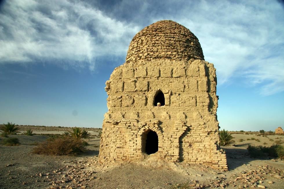
Photographs: Department of Archaeology & Museums national inventory record, displayed from the official source (doam.gov.pk). Not PWHI photography.
- Record ID
- 8541
- Province / territory
- Balochistan
- District
- Washuk
- Typology
- Monument
- Subtype
- Tomb
- Period
- Historic
- Legal status
- Not Protected — UNVERIFIED; no statute or notification cited
- Coordinates
- 27.98861, 63.04000 — source-provided, not field-verified
- Verification status
- source_record; automatically_standardized; verification_required
- Sources
- Shah, S. S. Ali. (2010). Archaeological Investigation along the proposed route of copper mining project from Chagi District to Gwadar Port. Ancient Punjab, Vol. I.
Found an error in this record? Submit a correction — quote record ID 8541.
Pakistan's Heritage Digital Ecosystem: Heritage Atlas · PWHI · Visual Record · Forum